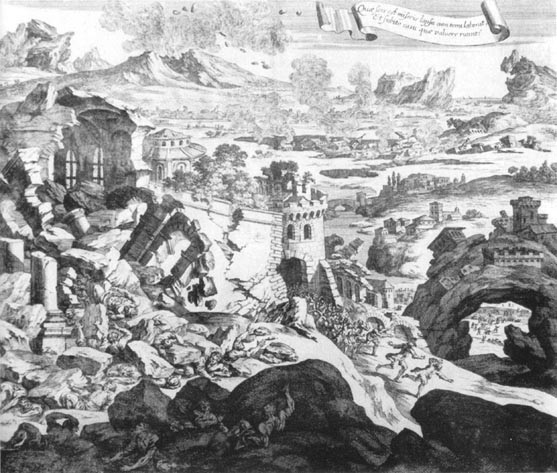
On 11 January 1693, the whole of Sicily was devastated by a very strong earthquake. A 7.4 magnitude tremor hit the eastern coast of Sicily, between Catania and Syracuse.
The devastating earthquake went down in history as the “Val di Noto earthquake”, destroying more than 45 towns and killing at least 60,000 people. The tremors were so powerful that they created a devastating tidal wave in the Ionian Sea, which reached Greece. It culminated in an earthquake swarm that lasted a few days. Two days earlier, on the evening of 9 January 1693, another strong earthquake hit the area, bringing down some buildings and causing deaths, albeit less violent than the one on the 11th. The earthquake on 11 January was followed by more than 1,500 aftershocks in the next two years. In as many as 70 inhabited centres, the intensity of the earthquake was greater than or equal to the ninth degree of the modified Mercalli intensity scale. There were also collapses and serious damage in Messina and in some towns on the north-east coast, including Patti and Naso; injuries and partial collapses occurred in Palermo, Agrigento, Reggio Calabria and more serious ones in Malta; slight damage occurred in some towns in southern Calabria.
The death toll was very high: in Catania around 16,000 people died out of a population of 20,000 residents; in Ragusa around 5,000 out of 9,000; in Lentini 4,000 out of 10,000; in Syracuse 4,000 out of 15,000, and in Militello 3,000 victims out of 10,000. In addition to being the most intense earthquake in Italy’s history, these numbers made it the second most disastrous earthquake on the peninsula, preceded only by the 1908 earthquake in the Strait of Messina (7.2 magnitude, but more than 120,000 deaths) and the 23rd most disastrous earthquake of all time (the Strait is in 12th place).
The only “positive” aspect of the 1693 earthquake was the reconstruction that followed. In fact, the architectural style used to rebuild the centres destroyed by that earthquake in the 18th century, Sicilian Baroque, developed. If today Noto, Ragusa, Catania, Syracuse and many other large and small towns in south-eastern Sicily boast fabulous artistic heritage, they owe it to the reconstruction, which set up the portents of Late Baroque art.